29 January 2018

The Capes


Cape Leeuwin, photo from Wikipedia
Where the Indian Ocean meets the Southern Ocean
The time has come to round the two notorious capes on Australia’s southwest coast. Cape Naturaliste takes you from the pleasantly quiet waters of Geographe Bay to the windy and cliff infested lee shores of the Margaret River wine country. That shoreline finally terminates 90 miles south, at Cape Leeuwin, where the Indian Ocean meets the Great Southern Ocean. From Cape Leeuwin it is a very long way to the next land mass.  It is about 2000 miles south to the Antarctica, or 1900 miles east to Hobart, Tasmania, or 5500 miles west to Cape Town, South Africa. No matter how you look at it, there is a lot of ocean in all but one direction and that is back to Fremantle. That is why Cape Leeuwin (Australia) is called one of the world’s three great capes, in company of Cape Horn (South America) and Cape of Good Hope (South Africa).
Gentle sail from Busselton Port Geographe Marina
to first night's anchorage at Quindalup. 
Still in protected waters of Geographe Bay

Cape Leeuwin is named after the first ship to have visited the area, a Dutch ship in 1622. Today a grand lighthouse warns mariners with its beacon of light that there are dangerous rocks and islets ahead. The lighthouse was commissioned in 1896 and produces a beam of light that still can be seen for 25 miles out to sea. The massive lens that gives focus to the light beam floats on a ‘bed’ of liquid mercury, virtually eliminating any rotational friction. Today the lens rotates through the power of an electric motor and the light is generated using electricity. Until 1982 the lens was rotated by a counterweight clockwork mechanism and the light was generated by kerosene that the light keepers had to hoist by hand crank daily to the top of the lighthouse.


In the modern age of navigation with GPS and electronic charting, navigating around the cape has become much less risky than in the days of old. What has not changed with time is the influence of the weather on navigating these seas safely. For us this meant a long and careful eye on weather patterns. Laurie read hours of blogs from sailors who have made that passage to glean every bit of weather strategy she could. We spent months studying weather models and historical weather patterns, all to improve our odds at having a safe and pleasant sail around the capes. Predominantly, a very strong wind blows from south to north along the coast between the two Capes. This wind pushes against the Leeuwin current that flows south along this shore making for a nasty sea mixed with the big swells rolling in from the Southern Ocean. Then once you round Cape Leeuwin and the offshore islands and rocks and sail east you will likely again face a head wind against a strong current.


Our view of Cape Leeuwin from 6 miles offshore, early evening
of January 25, 2018.  Finally the wind has turned southwesterly.
During one of our previous shore based visits to the Cape Leeuwin lighthouse, the wind was so strong from the east that it blew Laurie’s prescription eyeglasses right off her nose, they flew down the cliff never to be seen again! Ideally when picking a weather window to sail around this cape we look for a Southern Ocean low with associated frontal system to approach. We timed our Cape Leeuwin rounding to occur a day ahead of the frontal passage. This scenario often creates a light southerly along the Margaret River coast and a westerly once around the cape. Such was the case as we departed Geographe Bay on January 25th.  For once the wind forecasts held true.
 It was the ‘perfect’ weather window.

As a result, we had a delightful 300-mile sail to Albany. By the time we made landfall at Albany the evening of January 26th, the frontal system was breathing down our backs, the air was cooling off and clouds filled the sky, spitting the first few raindrops. Perfect timing, only wish that the weather gods were always so accommodating, but we all know better…

The day prior to rounding Cape Naturaliste we left the marina and anchored closer to the cape at Quindalup. At 2 a.m. the next morning with the Southern Cross overhead we hoisted our anchor and Katmai’s sails. We sailed northwest towards the cape in a light breeze, then rounding Cape Naturaliste with the first rays of the sun poking over the horizon. With the sails trimmed tight we began our sail south, first towards the southwest, then tacked back to the southeast, then back to the southwest, back and forth we went as we made our way south towards Cape Leeuwin. It was a lovely beat south, warm, sunny and comfortable. As the sun settled in the west for the day the Cape Leeuwin lighthouse stood proud and bright just to our north. We have sailed into the Southern Ocean and the capes are behind us!  It was a very good feeling.

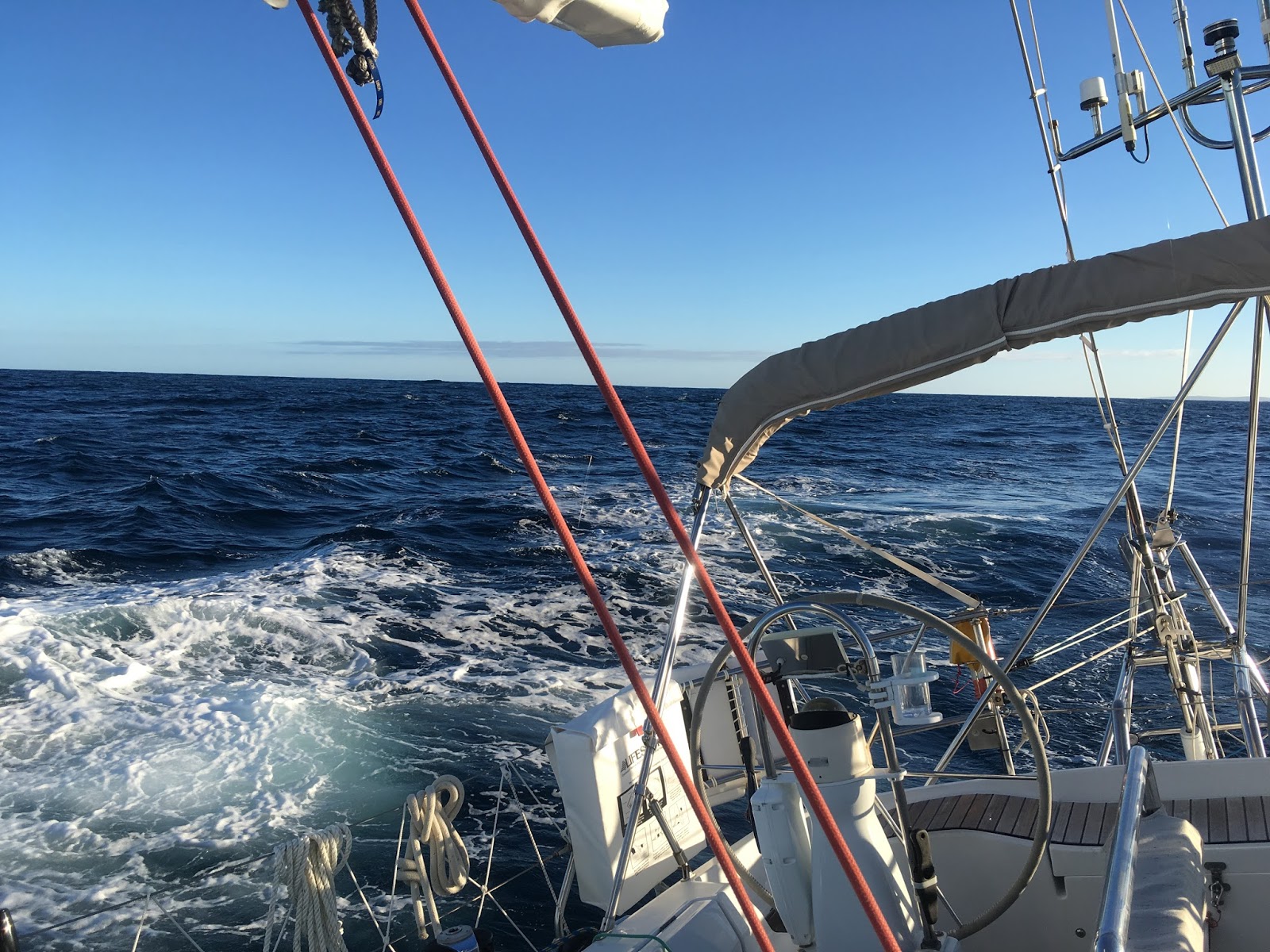
Sailing with a following wind in the Southern Ocean
Being in the Southern Ocean, the swells became noticeably bigger, but with a very long period. Katmai liked that as she became a bit livelier with an occasional surf down a wave and a slightly building breeze. Also, very noticeable was the birdlife, lots of Shearwaters began to trail us and even a lone Albatross stayed with us for an hour or so. Both birds are phenomenal experts in gliding. Rarely do they beat a wing as they skim with their wingtips inches above the waves, then rise on a wind shear only to repeat their glide down over the waves.


100's of shearwaters glided around us as we sailed
As day broke the next morning, we watched their seeming impossible flight for hours. With the new day the wind strengthened, but remained behind us. We finally dropped the mainsail to depower the boat in the rising breeze and continued under genoa only, still making 7 knots or better towards Albany. As the day progressed a distinct band of clouds moved over us, it was like a flat sheet with very sharp edges. The frontal system was not far away, but neither was Albany and our safe-haven. With night fall we rounded into King George Sound and were greeted by a band of bow wave riding dolphins.  
Katmai in Albany Water front Marina.
We made our way towards harbor using the navigation beacons the commercial ships use as our guide. By 10 p.m. we coasted into a slip in the marina and heard a kind call from a fellow sailor to throw him our mooring lines. As we tied-off Katmai and greeted our new neighbor he handed us the key to the marina’s hot showers. Ahhhh, a hot shower, there is not much more enjoyable than a hot shower after a 300 mile, 44 hour sailing journey around two notorious capes!
Now the wait begins for the next weather window to head to Tasmania.  In the mean time, we are going to enjoy some sight seeing around beautiful Albany.
King George Sound from the top Mt Clarence above the city of Albany.  Spectacular!


23 January 2018

Busselton Holiday


Maybe it wasn’t quite a holiday of the laid-back vacation type. We had a fair to-do list because of my (Eric’s)… well let’s be straight, dumb handling of house battery switches. After a good night of rest and dinner at the marina bar, we documented our to-do list. Order a new autopilot computer from France, rewire the alternator power cables and battery switches (to keep me from a repeat mistake), rebuild the mount for the autopilot ram, order and replace the engine alternator, order lots of fuses, order and replace LED stern light and fix/reconfigure numerous electrical instruments that got an electrical jolt. Plenty to do… But then this was one heck of a nice place to be stuck working on Katmai.

The Busselton mile long wooden jetty from the air (Wikipedia)
Eric overlooking the shore end of the jetty
Busselton today is a holiday/retirement community on the shores of Geographe Bay, about a hundred forty miles south of Fremantle, Australia. You guessed it, Busselton was first settled by the Bussell family in 1834 and became one of the earliest settlements in Western Australia. The settlement, being in proximity of tall and highly sought-after timber, became a leading seaport for the area. A jetty was built out into the shallow bay and a railroad was constructed to accommodate the timber export. Today the jetty still stands, but Busselton’s timber export is now only history. The jetty however has a new lease on life as a tourist attraction, it is after all over a MILE LONG! And it remains as the longest wooden jetty in the world!

Children's swim/play areas near the jetty
secured by perimeter shark netting. Made us want to jump in!
The marina we are in is a private marina belonging to a holiday home development and is called Port Geographe Marina. It is a first-class marina, with floating docks, hot showers, laundry, a chandlery, a boat yard and of course a great bar and restaurant with live music. Best of all are the people who run the harbor, harbor master Craig and delightful Karen who deals with all of us who want a slip/pen in the marina and always at the strangest hours of the day. While here we certainly enjoyed the Busselton coffee shops, the walks along the endless white sandy beaches, the bird watching by the massive inland wetlands and the sundowners at the marina bar/restaurant.
Oh yes, we came here to do repairs on Katmai. Magically all the bits and pieces began to arrive from various parts of the world and fortunately after installation all the systems are happy and working again. Peter’s design for the autopilot ram mount could drive an ocean liner, but hey Katmai doesn’t mind that comparison.

A bit of work and a bit of holiday and the weather gods in a good mood we departed Busselton for the next leg of our journey to Tasmania. This leg will take us around Cape Naturaliste and Caple Leeuwin to Albany on Australia’s south coast. Peter will meet us again in Albany for the Southern Ocean push to Hobart, Tasmania.
Long walks along the beach were delightful
Wonder what strange bird left these tracks on the beach ? :)


These "Friendly Swallows" leave
 reminders of their feelings for you all over your boat.
But we truly love waking to their delightful chatter at sunrise

Amazing sunsets in the Port Geographe Marina
 

15 January 2018

On our way, with a bit of a delay

Friend Peter and Laurie in the cockpit as we sail
 towards Garden Island shortly after departure.
On January 9th we departed for Tasmania! It was a lovely morning. A slight easterly breeze made for perfect sailing conditions down the Cockburn sound, through Challenger Passage and across the Five Fathom Bank. By late morning, the wind had predictably shifted to the south, of-course the direction we were headed. We tacked out towards the west and the wind continued to build, as it does every afternoon. 

By late afternoon it was blowing in the mid-20 knot range, and the seas were rather confused, probably by wind against current. Now 30 miles offshore, we decided to tack back towards Australia to continue our slog south. The seas by now were a couple meters tall, confused and coming at us from a couple different directions. As darkness fell the wind continued to slowly build and the sea-state grew more uncomfortable with it. Katmai's motion was never scary, but very unpleasant, especially for Eric who is prone to a bit of seasickness early in a journey. A lot of water spray was now flying across the boat as we plowed through the waves and swell. Fortunately, it was pleasantly warm out! Progress was slow however as we were bashing through something that felt more like a washing machine than an ocean.

At about 11pm, I woke Eric as we needed to prepare to tack back to the west and it was time for his watch. We were about 5 miles off the shallows near the shoreline north of Geographe Bay. In these conditions we wanted “all hands on deck”. After we tacked back towards the open ocean, we decided to run the generator, as the autopilot seemed to be working extra hard and using a fair bit of power. 

And then the totally unexpected happened!

In the darkness of the moonless night and Katmai feeling more like a bucking bronco than a proper yacht, Eric momentarily turned off the wrong battery switch. Instantly, everything onboard went dark! All lights, navigation instruments, GPS, radio, all dead. As the generator's power surged through the momentarily isolated electrical system, the popping of electrical fuses sounded like a popcorn machine at a movie theater!

With the autopilot now offline as well, Peter who was up in the cockpit and near the helm, jumped to the wheel to control of the boat as she was about to round up in to the wind. As Peter gained control of the helm he was being pelted by buckets of water and spray in the nearly 40 knots of wind. He has a high situational awareness, and maintained his orientation wonderfully despite the wind, waves and a pitch black moonless night. Because he was paying close attention to our position, he knew our previous compass heading and the distant shoreside lighthouse relative to our location. Because of this, we were not in any danger. 

We decided the best thing to do was to tack back in to the bay to gain more protection from the wind and sea conditions. This course also was somewhat towards the town of Bunbury, a harbor we knew well and is protected from the current weather. The harbor was 25 miles distant and cast a dim halo on the night sky horizon, it became our compass beacon. Peter aimed for it.

During the journey, we were marking our position on a paper chart every few hours. This was invaluable as it gave us a good feel for our current location and we could continue to plot our estimated progress.

In sail training courses, they teach you the skill of “dead reckoning”, the process of estimating your current location based on using a previous location, course and speed. Of course, you never think you will need to use the skill, let alone in a gale at sea on a moonless night!

And, you never expect to have all instruments and lights on a yacht to go out at once. It was such a shock!

Meantime below decks, the challenge was on to replace fuses on key equipment (GPS, Navigation Lights, and depth) while being basically on a roller coaster ride in a moonless night in gale. Fortunately, the radar came alive very quickly, this was great news as we were able to ‘see’ the shoreline and confirm our position. With replacement of another fuse, the depth sounder came alive as well! The navigation lights also worked. The radar and a working depth sounder were all we needed to make a safe nighttime approach to Bunbury.  The GPS fix eluded us until the next day. 

Eric relieved a drenched Peter at 12:30am at the helm and we dropped the sails and motored to Bunbury. This was the safest way to proceed due to near shore reefs. As it normally does, the wind eased as dawn approached and we made a safe anchorage at about 5:30 am in the early morning light. No one had really slept for 24hrs, so we slept like rocks until mid-morning and then started assessing and restoring instruments. In the end, the NKE autopilot computer was damaged by the electric jolt, despite being fused per manufacturers’ recommendation. It will need to be replaced. The good news is, other than autopilot computer, all electronics are back online after replacing numerous fuses. Most instruments needed to be reinitialized and reconfigured to properly ‘talk’ to each other.

The plywood that the autopilot ram was mounted on
 cracked due to fatigue.  Time for a redesign!
In a way, we were fortunate we went to port, during further inspection of the autopilot system, we discovered that the heavy marine-plywood and fiberglass platform which supported the autopilot ram had fractured. There were more than 5000 ocean miles on the ram mounting, and we are very glad we found this before heading off in to the great Southern Ocean.


The Busselton Jetty.  A mile long historical wooden structure.
We anchored near the buildings to wait
for the tide to rise so we could get in to the marina.


On Friday January 12, with our electronics back in working order, we set sail for Busselton and the very nice Port Geographe Marina. As we needed to wait for high tide to enter the marina, we anchored temporarily to the west of Busselton Jetty for a nice lunch break. 

Interestingly, the jetty is the longest wooden jetty in the southern hemisphere at more than a mile long. Used for loading lumber for more than a century, it is now a tourist attraction.


Katmai in the Port Geographe Marina
Here in the marina it will be much easier to get parts and do repairs rather than at anchor. We will likely be here in the marina for a few weeks to wait for a new autopilot computer, which will need to come from France.

Eric and Peter are already busy redesigning a new supper stout autopilot ram support. This time we are using 3.5-inch thick marine-ply with 5/16-inch thick aluminum angle bar supports ….. a much-improved design! We also will also have time to enjoy some hiking and birdwatching while we wait.

Peter will head back home for a few weeks and Eric and I will coastal-cruise Katmai bit further towards Tasmania. Peter will rejoin us, likely in Albany, for the crossing of the Great Australia Bight to Tasmania.
Sunrise in the Marina.